
Update: Forbes Bros. have shared propagation maps that outline the before and after coverage for the two tower sites. See below for explanation and link to maps.
The Eastern Ontario Regional Network’s (EORN) Cell Gap Project is a $300 million public-private partnership between the federal and provincial governments and Rogers to provide:
- 99% of the southeastern Ontario area from Ottawa to Haliburton with cellular voice calling services;
- at least 95% fo the area with standard-definition level services such as video-app calls, basic app usage and streaming of standard definition video; and
- at least 85% of the area with service levels that can support streaming high-definition video and more data-intensive apps.
The first phase (which began last year) was to improve the equipment on existing towers (including those in our area). The next step is to add new towers where necessary. We understand that a number of new towers will be proposed for Haliburton County.
We have been advised that as part of this process, two towers will be proposed to improve service in the Kennisis Lake area – one near the corner of Wilkinson Rd and Kennisis Lake Rd near the municipal waste transfer station and one on the north side near the bridge where Kennisis and Little Kennisis meet.
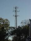
As the attached documents detail, the Wilkinson tower site will be located on private property at 1076 Wilkinson Road, approximately 275m SW from the Wilkinson Road and Kennisis Lake Road intersection. Specifically, the site will be located toward the center-east area of the property setback 223m from the access point off Wilkinson Road. Public access to the site will be limited by a fenced compound with locked gate. Rogers has proposed a 45m tall flush mount monopole tower at the above location. The structure is a single self-supporting metal tube anchored to a concrete foundation. The antenna equipment will be flush mounted to the top of the support pole to maintain a low visual profile. The total facility will be comprised of the tower support structure, antenna equipment, and a radio-equipment cabinet located in a 10m x 8m fenced compound. Although the structure is tall, it will comply with Transport Canada and NAV Canada regulations. Rogers anticipates this facility will not require any aeronautical obstruction marking or lighting.
The North Shore telecommunication site is proposed within a forested area on private property, setback 240m to the north from Watts Road and 185m to the east of Holts Road. Holts Road is a private road and an existing logging trail will be upgraded to access the site. Public access to the site will be limited by the existing gate at the Holts Road/Watts Road intersection. Rogers has proposed an 85m guyed tower at the above location. A guyed tower is three-sided lattice tower with three (3) sets of guyed wires that extend to supporting anchors. The site will be comprised of the tower, antenna equipment, and a radio-equipment cabinet located within a 7.6m x 9.5m chain-link fenced compound. Electrical services for the site will be extended from Watts Road along Holts Road and logging trail. The tower will comply with Transport Canada and NAV Canada regulations. Rogers anticipates the proposed tower will not require aeronautical lighting or marking protection.
The KLCOA appreciates that cell tower installations can be controversial. Property owners within 500 metres of the two locations will receive notification from Forbes Bros, who are representing Rogers on this issue. There will be public consultation meetings on November 23 and 24, 2022. See links below for pre-registration info.
In last year’s Kennisis All of Us survey, over 50% of respondents said that they were very concerned and over 90% said that they were at least somewhat concerned about cellular and internet connectivity around the lake. This is more than about convenience – we have heard repeatedly from people who have experienced safety concerns because of the lack of cellular connectivity in some areas, including the inability to reach 911 when required.
We will continue to share information on this process as it becomes available and encourage property owners to provide their input directly to the consultation mechanisms as they are identified.
For more details, maps and pre-registration info see:
Tower Proposal – Wilkinson Road
Tower Proposal – North Shore
| For coverage maps see below The colour coded maps show the measurements of Reference Signal Received Power (“RSRP”), a measure of signal strength in decibels (“dBm) from strongest -78dBm) to weakest/no signal (-200dbm). On these maps the strongest RSRP is dark purple, weakest is red and no signal is white. The water overlay on the maps hid the color coding for signal strength but please be assured the signal continues over this surface. Please note these coverage maps have the proposed tower at C4385 at 90m which has been reduced to 85m. This reduced height will not significantly affect coverage. Revised coverage maps will also be presented at the virtual public meeting. Coverage Maps |